Nikko / 日光 / ニッコウ is known for its natural beauty, World Heritage Sites, and relaxing atmosphere. While most people would go to Lake Chuzenji, Toshogu Shrine, Rinnoji Temple, and the Shinkyo Bridge or Kegon Falls.. my crazy friends and I decided to climb Mt. Nikko-Shirane / 日光白根山 / ニッコウシラネ which is located on the border of Gunma and Tochigi prefectures.
Mt. Nikko-Shirane is the highest mountain in Nikko National Park, and also the highest mountain in both Gunma and Tochigi prefectures. The peak of Nikko-Shirane is a lava dome featuring large cliffs, a small crater lake, and panoramic views of the surrounding mountains including Mt. Nantai and Lake Chuzenji. It is also listed in the 100 famous mountains in Japan.
OCT 26, 2024 (Saturday) – The road going to the trailhead is the infamous Irohazaka winding road or Iroha Slope that has a total of 48 sharp curves. Definitely not for beginner drivers like me so I skipped driving here. This road is a popular spot for Autumn Foliage viewing. We even saw monkeys on our way and going back. I suggest you take motion sickness medicine for this though because it was a rough ride.

There is a campsite nearby if you want to stay the night before. We are coming from Tsukuba so we just left early to get there around 7:00 for an early start.
We planned on taking the ropeway initially but decided to start from Suganuma Trailhead instead. There is a parking lot near the Hishiya Suganuma Sales Office Yamakoya and most people parked here. This is the only toilet we saw and no toilet after this or at the summit or nearby the pond so make sure you go to this one here if you’re taking the same route as ours.


We parked further inside after passing by Shirane Trailhead sign all the way to the parking lot near this sign below.

Meet the gang: Me, Roberto, Sonia, Shinobu, Micah, Jade
TIMELINE
8:00 – Started our ascend. It was about 10°C so I had my fleece jacket on. It started out really nice.. for like 5minutes.

IMMEDIATE REGRET.
I thought I learned my lesson the last time I hiked on very little sleep, but I still couldn’t sleep the night before this hike — even though I was exhausted after my 11-hour shift. I tried to sleep, but my body just wouldn’t cooperate. I think I only managed about 2–3 hours.
Does anyone have any tips for sleeping better before early hikes? If you do, please share!

9:45 – We reached Midagaike / 弥陀ヶ池 / ミダガイケ (The smaller pond in this route). Here we ate our breakfast and had coffee. I really like the view here. They have some benches too around the pond where people can eat and just admire the view.

10:25 – We started heading to Mt. Shirane summit. There is also a way to the Goshikinuma Pond / 五色沼 / ゴシキヌマ which is less steep than the one we took. So if you only want to visit the pond, you can simply turn left here and follow that trail instead.

From here on, the ascent started getting really tough for me — but the views were absolutely amazing! You could see the emerald waters of Goshikinuma Pond from above, and it made everything so worth it.

STAGE 4: REGRET. What did I get myself into?
11:30 – We reached a rock formation that we climbed for the obligatory summit shot.
The trail leading up to this rock section was extremely steep, and I was really struggling. Roberto was kind enough to offer to carry my backpack — thank you so much, Kuya!
If you’re a beginner, I suggest carrying a smaller and lighter bag — something that doesn’t restrict your movement when climbing big rocks. I made the mistake of overpacking for this hike, and I didn’t even use most of the items I brought. They just turned into unnecessary extra weight.


11:45 – A little past this rock formation, we reached a landmark of Mt. Shirane and thought this was the summit — but the actual summit marker was still further ahead. You have to descend a bit and then climb back up again.
By that point, we were so hungry that we decided to eat first. Roberto boiled water for our cup ramen and coffee. I had brought a lightweight down jacket just in case it got really cold, but since the temperature at the summit was around 14°C, my fleece jacket was more than enough.


12:35 – After lunch, we finally made it to Mt. Shirane Summit (2,578 m asl).
The panoramic view from up here was absolutely amazing. We could see Mt. Nantai, other mountain ridges, emerald-colored lakes, and a sea of clouds stretching into the distance. We got lucky with the weather again — the forecast said light rain, but it didn’t rain at all. It was a little cloudy at first, but it eventually cleared up, and the temperature was just perfect.

At first, I wasn’t sure if this was the actual summit marker because it looked different from the ones I had seen online. (In other people’s photos and vlogs, there were two wooden summit markers, so I wasn’t certain if we were even at the right spot.) But this was where everyone was lining up to take photos — so we did the same.

13:00 – We started our descent after taking photos and began walking toward Goshikinuma. My phone died around this time, and I think that’s why my YAMAP activity history ended up messed up on the app.
I’m not 100% sure which exact path we took in this area. According to the map, it looks like we went in a straight line from the shrine landmark to Mae-Shirane and then down toward Goshikinuma Pond — but I honestly don’t remember it that clearly. I don’t think we passed by the Goshikinuma Mountain Cabin , but since we did go through Mae-Shirane, maybe we actually did follow the straight route after all?

I was pretty confused about which way to go down while planning this hike and looking at the maps, but this time we just followed Roberto since it was already his fifth time hiking here. If you’re going on your own, though, I highly recommend using a map or an offline navigation app like YAMAP, because the trails in this area can get quite confusing.

Our descent was pretty rough — lots of rocky terrain (it reminded me of Mt. Fuji’s descent). But the dormant trees gave off strong “winter is coming” vibes, which I actually loved.

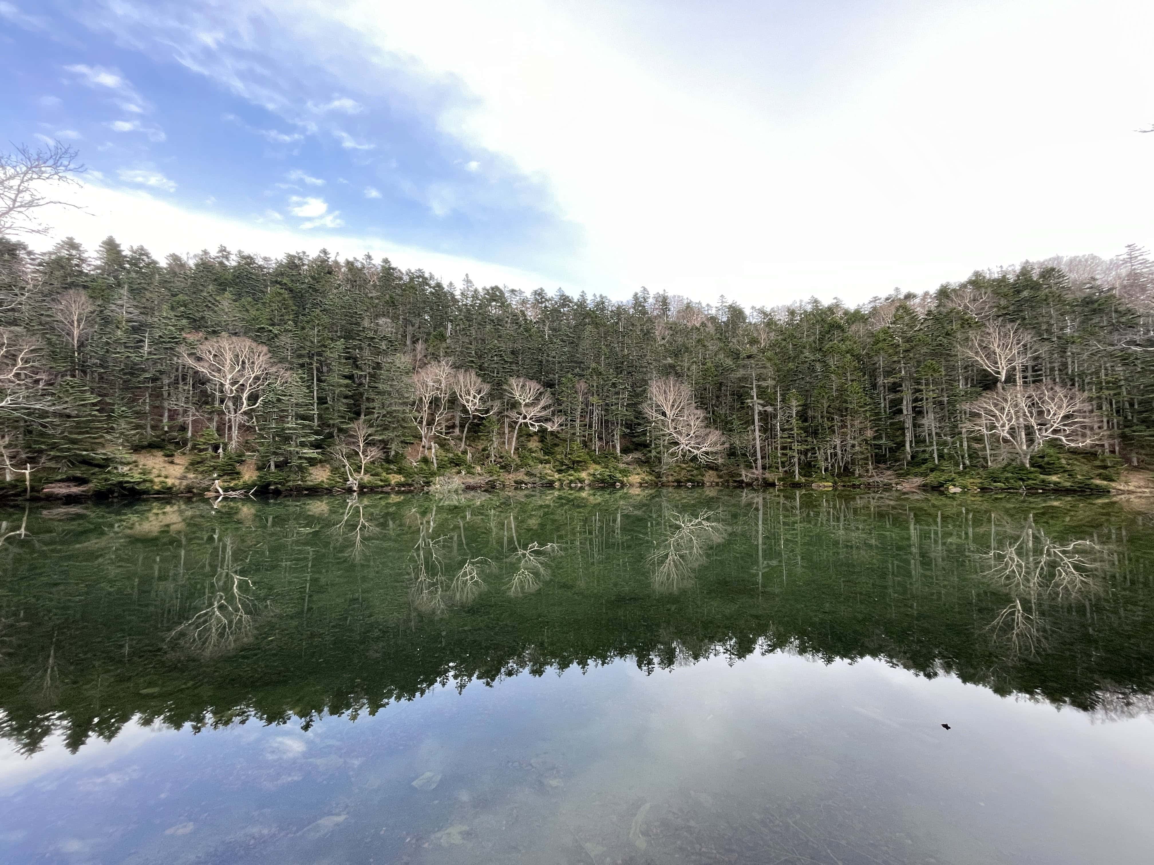
14:20 – We finally reached Goshikinuma , the emerald colored pond. The reflection of the dormant trees on the water makes it a really cool backdrop for your next holiday postcard.
14:45 – We left the pond and headed back toward the smaller pond, Midagaike. There was a bit of ascent and descent along the way, but it wasn’t as tough as earlier sections.
15:15 – We reached Midagaike. From here, it was about a 3.3 km walk back to Suganuma Trailhead / 菅沼登山口 / スガヌマトザングチ, and it took us around 1 hour and 15 minutes. It felt never-ending. It didn’t seem this long when we were climbing up, but going down definitely felt much longer.
I even hit my left knee twice on a big rock, so be extra careful on the descent — especially on the rocky sections of the trail. My knees and ankles were really starting to hurt, and it became quite hard to walk.
16:30 -We arrived back at the trailhead.
After our strenuous hike, we looked for a nearby onsen to soak away all the body pain and ended up going to NikkoWanoshiro Onsen. We paid ¥700 each, and I had to buy towels since I didn’t bring any — the big towel was around ¥400 and the small one about ¥300 (I think?). The traffic was terrible, and it took us almost 2 hours to get there.
I liked this onsen, but the outdoor bath was quite small. They do have a sauna, but there wasn’t a cold-water bath — only a cold shower. I enjoy alternating between hot and cold baths, so I really wished they had one. But at that point, I honestly didn’t care anymore — I was just happy to feel any hot water on my tired body.
After onsen we had dinner at Enya. The food was really good, and the customer service was superb. I remembered eating here 11 years ago when I first visited Nikko (and also the last time before this), and I still highly recommend it. It’s a place that’s especially popular with Japanese locals.
HIKE LOG
Mt. Nikko-Shirane (2,578 masl)
Total distance : 8.6km
Hike time : Start 8:00 – End 16:30 (Including lunch break in the summit)
Ascend : 3 hours and 50 minutes (Including mini breaks)
Descend : 3 hours and 30 minutes (Including mini breaks)
Total breaktime : 2 hours 43min (from Yamap) This includes a long lunch
Backpack weight : I didn’t weigh it but I estimate around 5-6kg?
Water : 1L pet bottle plus 650ml tumbler (I forgot to buy ice but I thought its gonna be okay since it’s not that hot but I think I still prefer ice cold water while hiking.)
Difficulty : This was harder for me than Karamatsu hike.
Yamap Hiking route HERE. (Disclaimer, my phone died after the summit so it might’ve affected the gps recording)
I would really love to come back here again, but next time I think I’d like to take the ropeway and enjoy the view from the observation deck too. I’ve heard it’s amazing. Then maybe I’ll just head straight to the pond and have a picnic there — I think it would be a really nice option for beginners.
Or I’ll see how I feel that day and then decide if I want to push for the summit. Either way, I’d still go down via Goshikinuma Pond because the view there is absolutely beautiful.
Thanks for reading and I would really appreciate it if you leave a comment 🙂
#MarieJournals
I organize hikes in Kanto area and always looking for joiners so feel free to send me a message if you want to join us.